Monsoons, part of the rainy season cycle in the Philippines, are both a norm and a hazard. Compounded by typhoon activity, which will be explored later, monsoon rains can lead to flooding and landslides.
Monsoons are a natural part of the weather cycle in the Philippines, that have to do with the effect of difference in temperature between the ocean and land on the sea breezes. NOAA monitors global monsoon activity in their Climate Prediction Center. This information on ocean temperatures is available online for anyone to access.
(Table from NOAA)
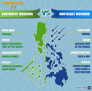
In the Philippines, there are the summer monsoons (June-November), the "rainy" season, that move westerly and bring heavy drenching rainfall, and there are winter monsoons (December-May) that move easterly, and can bring dry conditions (and sometimes drought). The Philippines has between 70% and 85% humidity, year-round, and there is also rainfall year-round.
(Graphic from Panahon TV and PEGASA)
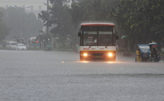
Monsoon seasons are unpredictable, they can start early or start late, bring too little rain or bring too much. This can create significant problems for growing food and tending livestock, as well as for dealing with the secondary consequences of flooding, mudslides, landslides, and sinkholes.
(Photo from Photos of the Week, Sf.Co.Ua, August 2012)
PAGASA (Philippine Atmospheric, Geophysical and Astronomical Services Administration) is the weather monitoring agency in the Philippines, they issue weather warnings about rain, typhoons, and flooding. They are responsible for forecasting for aviation and marine hazards that could impact transportation and shipping, and they also issue impact assessments for agriculture. They have a rainfall and thunderstorm warning system, on a spectrum of advisory-alert-emergency for rainfall, and information-watch-advisory for thunderstorms, the outreach methods besides their website also include social media and SMS messages to affected areas. There is also a PAGASA app for android phones.
(Photo from Photos of the Week, Sf.Co.Ua, August 2012)
References: http://www.cpc.ncep.noaa.gov/products/Global_Monsoons/Global-Monsoon.shtml, http://www.wrh.noaa.gov/twc/monsoon/monsoon_whatis.pdf, http://www.pagasa.dost.gov.ph/, http://www.pagasa.dost.gov.ph/index.php/climate-of-the-philippines, http://www.pagasa.dost.gov.ph/index.php/agriculture/impact-assessment-for-agriculture, http://www.pagasa.dost.gov.ph/index.php/20-weather/29-rainfall-warnings, http://photo.sf.co.ua/id22
Friday, October 28, 2016
Friday, October 14, 2016
Mass Wasting-Landslides & Mudslides in the Philippines
Unfortunately the islands of the Philippines are highly susceptible to mass wasting. Not only is there a significant amount of coastline, but most of the islands are mountainous, and the upland areas and areas near volcanoes are particular vulnerable. Increasing the risk are earthquakes, high rainfall, typhoon and monsoon activity, and volcanoes. Increasing the hazard is the development of upland areas, homes on slopes, homes made of flimsy building material, and lack of reinforcement and drainage infrastructure.
(Photo from PHIVOLCS)
PHIVOLCS is particularly concerned with earthquake-induced landslides, and therefore they have a hazard map outlining the various levels of hazards. They have hazard maps available by region as well, that are more detailed.
It is not surprising that they have focused specifically on this landslide hazard because of the deadly 2006 Southern Leyte mudslide that claimed the lives of over 1,100 people. This landslide was the result of a period of heavy rainfall followed by a very small M 2.6 earthquake, burying an entire village including an elementary school that was in session at the time, killing all but one child and one adult at the school, as well as a thousand others in the village of Saint Bernard. Possible contributing factors were logging and mining activity in the area. A previous landslide in 2003 claimed the lives of 200 people in this same area. Although some residents were aware of the danger in 2006 and had evacuated, some returned too soon, encouraged by the rainfall subsiding, and were caught in the mudslide.

(Photo from Robert Peterson, US Navy)
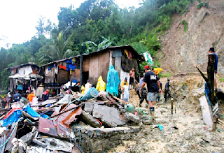
September and October are considered high risk months for landslides because of late season typhoons. Just one of many landslides in 2013, the photo below illustrates the slope conditions, soil texture, and building materials that resulted in the death of at least 10 people in Barangay Cawag.
(Photo from Philippine Star Global)
As far as methods to reduce landslide hazards, very few are evident from my research. The main strategies seem to be community engagement through education and memorial events, and decentralization (or rather the strengthening of the responsibilities of individual provinces to address their hazards within their own jurisdictions). Also, just simple things, like improving communication throughout the country can help with disaster management and issuing warnings for vulnerable areas, and reliable communication systems are not currently widely available throughout all the Philippine islands.
References: http://www.navy.mil, http://www.phivolcs.dost.gov.ph/index.php?option=com_content&view=article&id=82&Itemid=500025,
http://www.philstar.com/headlines/2013/09/24/1237497/landslides-floods-kill-22-zambales, https://www.scribd.com/document/70631853/Strengthening-Disaster-Risk-Reduction-in-the-Philippines-Strategic-National-Action-Plan-2009-2019
Unfortunately the islands of the Philippines are highly susceptible to mass wasting. Not only is there a significant amount of coastline, but most of the islands are mountainous, and the upland areas and areas near volcanoes are particular vulnerable. Increasing the risk are earthquakes, high rainfall, typhoon and monsoon activity, and volcanoes. Increasing the hazard is the development of upland areas, homes on slopes, homes made of flimsy building material, and lack of reinforcement and drainage infrastructure.
(Photo from PHIVOLCS)
PHIVOLCS is particularly concerned with earthquake-induced landslides, and therefore they have a hazard map outlining the various levels of hazards. They have hazard maps available by region as well, that are more detailed.
It is not surprising that they have focused specifically on this landslide hazard because of the deadly 2006 Southern Leyte mudslide that claimed the lives of over 1,100 people. This landslide was the result of a period of heavy rainfall followed by a very small M 2.6 earthquake, burying an entire village including an elementary school that was in session at the time, killing all but one child and one adult at the school, as well as a thousand others in the village of Saint Bernard. Possible contributing factors were logging and mining activity in the area. A previous landslide in 2003 claimed the lives of 200 people in this same area. Although some residents were aware of the danger in 2006 and had evacuated, some returned too soon, encouraged by the rainfall subsiding, and were caught in the mudslide.

(Photo from Robert Peterson, US Navy)
September and October are considered high risk months for landslides because of late season typhoons. Just one of many landslides in 2013, the photo below illustrates the slope conditions, soil texture, and building materials that resulted in the death of at least 10 people in Barangay Cawag.
(Photo from Philippine Star Global)
As far as methods to reduce landslide hazards, very few are evident from my research. The main strategies seem to be community engagement through education and memorial events, and decentralization (or rather the strengthening of the responsibilities of individual provinces to address their hazards within their own jurisdictions). Also, just simple things, like improving communication throughout the country can help with disaster management and issuing warnings for vulnerable areas, and reliable communication systems are not currently widely available throughout all the Philippine islands.
References: http://www.navy.mil, http://www.phivolcs.dost.gov.ph/index.php?option=com_content&view=article&id=82&Itemid=500025,
http://www.philstar.com/headlines/2013/09/24/1237497/landslides-floods-kill-22-zambales, https://www.scribd.com/document/70631853/Strengthening-Disaster-Risk-Reduction-in-the-Philippines-Strategic-National-Action-Plan-2009-2019
Subscribe to:
Posts (Atom)


